

Connecting merchant vessels and pleasure craft across the globe
Connectivity where and when you need it
now with navigational backup in GNSS denied areas

Two LEO services for higher speed with lower latency than GEO
Onboard equipment for automatic failover, load balancing, link bonding
The right tools to manage your bandwidth and prioritize usage
Iridium A-PNT navigation backup in GNSS denied areas
Add a global cellular plan for connections in port and coastal waters
Flexible data plans for both Starlink and OneWeb
OneWeb antenna leasing from 24 to 60 month terms
What makes our hybrid network solution superior?
Everyone knows what Starlink is, but what is OneWeb?
OneWeb is another LEO satellite constellation offered by Eutelsat, one of the world’s largest satellite operators:
600+ satellites orbiting at 1200 km in 12 orbit planes
40+ ground stations around the globe
How is OneWeb different than Starlink?
Unlike Starlink, OneWeb focuses on enterprise customers who need an SLA with a committed information rate (CIR)
Higher orbits mean fewer satellites for complete coverage and fewer handoffs between satellites for greater stability
For now, OneWeb has regulatory approval in India, Saudi Arabia, and the UAE
There are no crosslinks which means satellite signals go up and down in the same region
Minimize your operating costs
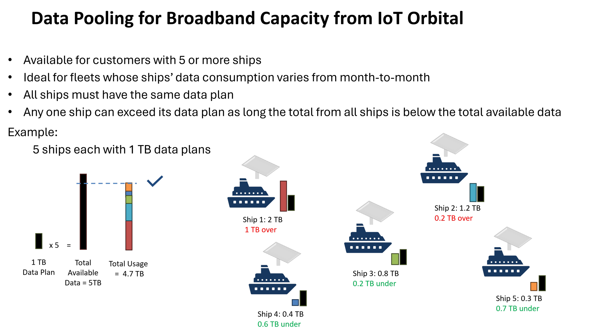
Pool data across your fleet
Add cellular connectivity to reduce dependency on satellites
Automatically switch services based on cost and usage
Control how much bandwidth your crew uses
Use our video-on-demand service to reduce bandwidth for entertainment
Iridium Navigation Backup for GNSS Denied Areas
IoT Orbital’s solution is a rugged, maritime-grade, above-deck terminal that provides resilient, assured positioning, navigation and timing (A-PNT) using the Iridium satellite network even during GPS/GNSS jamming or spoofing attacks. It offers 1/min to 1/hour reporting, geofencing, and simple Bluetooth setup, making it ideal for shipping, defense, and vessel security. It features:
o Assured Positioning: Detects spoofing by comparing standard GPS with Iridium’s authenticated PNT signal.
o Simple Deployment: Single, discrete dome unit with optional bridge view; no complex below-deck electronics required.
o Maritime Tough: IP67-rated waterproof housing for harsh marine environments.
o Data Integration: Connects to Ground Control’s Cloudloop Tracking independently of any other communications and offers API/webhook support for integrating, viewing, and logging events.
o Increased Visibility: Provides a dependable second position source for vessel tracking in contested areas.
o Power Cut Resilience: Battery backup assures continuous tracking/reporting via Iridium even if vessel power is interrupted.
o Additional accessories include:
o State of the art marine grade chartplotter with 9 in. display for seamless connectivity with the terminal.
o Ruggedized version of the chartplotter with 9 in display.